
Whew! It took longer than usual for Apple to approve FlyQ EFB 3.2.1 but they finally released it. Watch the short video to see what’s new.

Version 3.2.1 of FlyQ EFB, as the “.1” part might imply, was more designed to fix bugs and improve stability than add new features. In keeping, it fixes several dozen bugs and makes many improvements to stability. These are all listed towards the bottom of this post. Not very exciting but I think you’ll agree that reliability is pretty darned important in an aviation app.
But (and you knew there was a but) we also added one very important new feature, and did it in a way that goes well beyond similar features in every other app out there. That feature:
Tail numbers on the map for ADS-B traffic targets
You may be thinking “Yawn, every app has that.” If you were, you’d be right, which is why we came up with two totally unique and very useful twists to the feature:
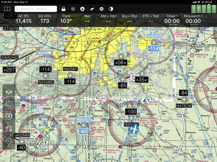
The Buddy List. You can add the tail numbers of your friends’ planes and FlyQ highlights those targets in blue (like N9335X and N463SR below) so they standout. Incredibly handy and I bet it becomes one of your favorite features in the app.
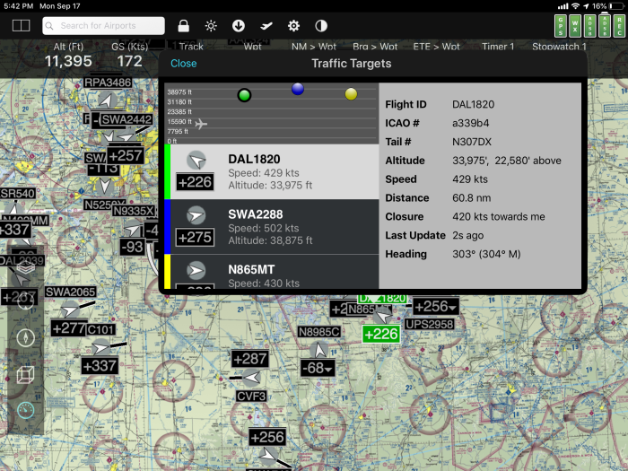
Traffic Popup. When you tap an area with multiple traffic targets, you’ll see a popup that shows details about each target near the tap. In addition to a list of targets, FlyQ displays the vertical location of each target relative to you using different colors (the colored balls at the top of the popup) similar to the way we display AIRMETs and SIGMETs. When you select a particular target, it’s highlighted on the map for additional clarity (e.g. DAL1820 is green on the map below).
To upgrade from an existing iPad or iPhone installation:
Go to the App Store icon on your iPad or iPhone and select the Updates tab. Click the Update button next to FlyQ EFB. Note: If your device is set to automatically update apps, you may see an Open button rather than Update because the new version has already been installed.
To download to a new iPad or iPhone:
Go to the App Store icon on your iPhone or iPad, select the Search tab, enter FlyQ EFB.
What’s New in 3.2.1
- ADDED: Optionally displays tail numbers of ADS-B targets
- ADDED: New ADS-B “Buddy list” highlights your friends’ planes
- ADDED: Detailed display of ADS-B target info when you single-tap one or more ADS-B targets on the map
- ADDED: Automatically turns on the map’s Traffic layer when an ADS-B system is connected
- ADDED: Substantial reliability and performance improvements when downloading monthly ChartData
- FIXED: Does not display Colorado charts properly and downloading Colorado could affect all maps at certain zoom levels
- FIXED: In rare cases, the main ChartData navigational database (airports, etc.) gets corrupted and unusable with missing airports, navaids, etc.
- FIXED: Does not display all ADS-B radar correctly in rare cases
- FIXED: Small memory leak in ADS-B traffic may cause older iPads to crash
- FIXED: Sometimes the app does not restore previously selected map layers at app startup
- FIXED: ChartData Manager downloaded percent numbers are sometimes wrong
- FIXED: In the ChartData Manager, the IFR High switch is reset to off during every app update
- FIXED: Memory leak that can cause crashes when downloading data for many states
- FIXED: Send/Receive reversed for Avidyne IFD
- FIXED: Documents fail to sync when added or at startup in some situations
- FIXED: Personal Waypoints and AIRMET/SIGMET layers do not show properly at startup
- FIXED: iPhone only: Done button on a Document goes to the wrong screen
- FIXED: Slingshot now provides the Certified Plates file for certified avionics
- FIXED: Document drag/drop into folders does not work
- FIXED: Reversing flight plans does not reload the plan on the map in all cases
- FIXED: Recorder sometimes starts new tracks rather than create one contiguous track
- FIXED: Multiple problems decoding certain latitude/longitude strings
- FIXED: Gauges not always updated on flight plan change
- FIXED: Tap into the Search field on the iPhone version does not behave as expected to position the cursor
- FIXED: Recorder does not play tracks properly when the Tracks layer is off
- FIXED: Multiple problems with the integrated Simulator
- FIXED: ADS-B Battery indicator always flashes with Lynx and Echo ADS-B systems
- CHANGED: Move all the ADS-B Setting options to one category (“ADS-B / Devices”)
- CHANGED: Use internal or external GPS when not getting track or speed from Avidyne
- CHANGED: Double-tap on closed airports now shows info about the airport
- CHANGED: Background color on ADS-B Connect/Disconnect was too hard to see
- CHANGED: Slingshot now OFF by default to save battery life
- KNOWN ISSUE: Slow memory leak in the ChartData Manager may cause a crash after a very large number of states are downloaded, especially on older iPads
- KNOWN ISSUE: The TFR map layer sometimes stays on even when switched off.

Thanks large: Superb and getting better software and support.
LikeLiked by 1 person
Thanks so much, John!
LikeLike
Any chance that audio alerts for traffic and/or terrain will be implemented in a not-so-far-away version?
LikeLike
Yes actually. It’s definitely something in the pipeline.
LikeLike
Steve, The traffic audio alerts is also important to me. Thanks, Tim
LikeLiked by 1 person
I am flying a single engine aircraft and I nearly got run over by a Cessna Citation on Final for the ILS today (non-towered airport), so an audio alert would be great to have. He was 500 feet on top of me and apparently did not hear my radio calls for the past 30 minutes as he was busy listening to another airport (???). Foreflight has one..ahem..
LikeLike
Yikes! Glad you’re OK. Adding an audio alert is on our list to add. However, a few caveats 1. Most people don’t have an audio panel such as to allow them to hear anything from the iPad 2. If would only work if you have ADS-B Out. Why? Without ADS-B Out, you very often see a shadow of yourself on the screen as you’re actually receiving target data meant for someone who has ADS-B Out — and you are a target for them! With ADS-B Out, you send your N-Number to the FAA so they relay it back in messages, allowing us to filter it out.
LikeLike
Note, the citation did not identify himself as such until he was on top of me. He just gave his N number.
LikeLike
This update was not there to update at the App Store. Thanks Jim
Sent from my iPad
>
LikeLike
Should be there by now as they released in yesterday afternoon. Make sure your iOS device is running version 9.3 or later and check back with the App Store. We’ve had a whole lot of folks already update so I’m sure it’s there. Might want to kill and restart the App Store.
LikeLike
Steve, can you comment on the traffic we are seeing on the screen as it relates to altitude? In your video you commented about ghosting occurring because of things such as TIS-B re-broadcasting your own aircraft but doing so using the pressure altitude that was encoded via your transponder, which could be off by a few hundred feet and thus appear as a new target. I’ve seen this myself first hand, not just the ghosting but the fact that my transponder was showing a reported altitude a few hundred feet below what GPS and Altimeter were showing. I understand the theory of why pressure altitude is used for the transponder alt encoding in order to keep things consistent across all aircraft, what I’m curious though is how this information is then dealt with in FlyQ when it has been brought back in via ADS-B/TIS-B? For example, say I’m flying at FL045 as shown by GPS/Altimeter and I’m seeing traffic around me that shows they are flying -300 feet lower than me. Naturally, depending on how close they are, I’m going to be looking down slightly to find them. Now lets say I look down at my transponder and see it is also reporting -300 feet lower than true altitude. Does this mean that traffic being displayed in FlyQ is really at -300ft to me or is it ACTUALLY at my exact same flight level since it received pressure alt, which was off by -300 feet? I’m not sure how traffic is relayed to FlyQ from an ADS-B In unit, so I didn’t know if FlyQ receives a feed that it knows is pressure altitude for targets and then applies it’s own correction based on what it knows of my aircraft pressure vs. true altitude, or does it just display it exactly as it receives it? Hope this question makes sense?
As a follow-up. I’m sure I will not be the first person to ask this question as we learn more about ADS-B, rebroadcasted messages, transponder alt encoding etc. I’m wondering if it would be smart to somehow further designate what altitude is being referenced in FlyQ when you click on a target and get the details? Currently the details of the target have the label “Altitude.” Should this label maybe be changed to “Pressure Altitude” if that’s what it really is, or “True Altitude” or “Corrected Altitude” or “Density Altitude” (you catch my drift.) If I had seen a bit more description on the details page for a target, then I would know exactly what altitude FlyQ is displaying for targets and wouldn’t have to question this.
Obviously at some point someone is going to reply to my question with “dude, if you are worried about 300 feet, you are too close.” Recently I had just taken off from my home airport and I made a radio call that I was remaining in the pattern and turning left cross-wind. While gaining altitude and just coming within TIS-B service, I was about to turn left base and my TIS-B alert went off that there was an aircraft within maybe 500 feet of me and displayed it on my Garmin 430. This obviously shocked me and nobody had made a radio call that they were in the pattern or coming in. I don’t recall now if it showed the same altitude, lower or higher as it happened so fast. My passenger (a CFI) found the traffic immediately and said “make a tight left circle right now, you have a Bonanza passing below us by a few hundred.” The #$(@ Bonanza entered the pattern at the corner of crosswind/downwind and never made a radio call on entry (he made radio calls after but never with his tail number, did a T/O and bolted out of the area as quick as possible.) Obviously I didn’t have much time to process, BUT, if my TIS-B had said he was at my same flight level but was actually above or below me because it was reporting pressure vs. a calculated level, then the evasive maneuver I might have taken could have made a close call even worse.
Thanks in advance for any clarity you can provide on this.
LikeLike
Great question! I can’t speak as to why the FAA decided on Pressure Altitude (Mode C Altitude Encoder) instead of GPS for traffic. Why require the installation of a GPS WAAS source for ADSB OUT after all. Right?
The challenge is most portable devices do not benefit from a Pitot-Static system so GPS is used instead. This helps to keep system costs down and simplifies installation. While some portable devices include a barometer sensor, this has its limitations and is subject to ‘alternate static source’ effects.
There is multiple possible solutions and we’ve been researching them all. Please feel free to contact me directly if you have any questions.
Thanks, Keith
LikeLike
” I can’t speak as to why the FAA decided on Pressure Altitude (Mode C Altitude Encoder) ”
Well I did enough research to fully understand why. At the time of coming up with altitude encoding, the technology for pressure altitude was possible while GPS was still very new for airplanes let alone WAAS. Density altitude requires knowing the altimeter setting. They went with pressure altitude so that all aircraft report the same thing, and then ATC applies the altimeter adjustment after the fact when viewing their radar screens so they talk to us in terms of MSL even though the data was collected as pressure altitude. That’s all good and works out great with ATC until WE are now the ones receiving the pressure altitude digitally. I know ATC is converting pressure altitude to MSL, but my question is, is FlyQ? If so, how? They don’t have the reported altimeter setting like ATC does, so my assumption is they would have to do something with seeing the own ship reported back with pressure altitude and then compare that to GPS to get an idea of what the difference is so it can apply that same correction to the other aircraft.
I recently stumbled on a forum post that was discussing the various EFB’s and listed the ones that incorrectly report the incoming pressure altitude as MSL, while other EFB’s applied a correction to the pressure altitude to provide MSL.
https://github.com/cyoung/stratux/issues/348
So the question my favorite FlyQ dev’s… what are you displaying to us? Pressure Alt or some type of calculated MSL, or does ADS-B somehow encode and send a correct altitude to ADS-B receivers that you are using?
LikeLike
From page 96 of the Pilot’s Guide:
Note: The relative altitude may be a little off because FlyQ compares your GPS altitude to the pressure altitude encoded in the ADS-B feed.
Now …
Trying to correct using a pressure sensor in a portable device is not my favorite way to handle this. We tested some units and found the “corrected” version to be less accurate than simply clearly noting that we’re using two slightly different alts to compare (and, of course, totally useless in a pressurized cockpit). That doesn’t mean we won’t offer that option in the future but my preference would be to use more accurate pressure readings from an in panel device like the Dynon SkyView or Avidyne IFD. We do plan to do that in the future. We also looked at elaborate systems like using the data from a nearby METAR to adjust the alt and found it to be MUCH less accurate than what we do now. Perhaps we didn’t get the math right and with the adjustment and can look into it more later but we did evaluate this option about a year ago.
LikeLiked by 1 person
FlyQ EFB 3.2.1 is a great upgrade, probably the best upgrade done by Seattle Avionics on Fly Q EFB, and for me personally I love the changes to the traffic targets. That will really help while “clearing” for close in ADS-B traffic. Downloading Fly Q EFB 3.2.1 and Chart data was much quicker and without any hiccups. I appreciate the change in color of the ADS-B connect/disconnect to charcoal but it is not very noticeable on the Weather page since the other banners there are charcoal in color also. How ’bout making the banner yellow/orange to make it more obvious? That is really minor, though. Keep up the good work on refining Fly Q EFB, it’s the number ONE EFB program now, without a doubt.
LikeLiked by 1 person
Wow! I’m blushing, Paul — which is particularly hard for me right now as I’m exhausted 😉 Thank you so much for the kind words. I also agree with changing that color even more and, just now, chatted w/ a developer about it for v 3.3. Thanks!
LikeLike
Thanks Steve for your response, I wish I could reply back directly to your reply to keep the thread all nice and organized but wordpress only seems to allow replies one layer deep.
In reading on other forums, the struggle you describe is the same struggle all EFB’s have been dealing with. Do they use the pressure sensor built into an iPad, which is using the pressure in the cabin, or do they try to obtain it from something else?
I’m not sure how everyone else feels about this, but I personally am fine with FlyQ displaying targets as pressure altitude, just so long as I know that’s what I’m looking at. The problem I had is that I wasn’t sure what was being presented because there was no additional designation on the altitude labeling? I didn’t know if you were actually presenting pressure and I need to correct it myself, or if you were attempting to correct it and present it as MSL. It sounds like you are saying you are attempting to correct it and present MSL as best as you can given various limitations. Is that correct?
As I stated before, regardless of the struggles involved with correcting it as best as you can, I do think it might be important to list what altitude you are attempting to represent by way of the details page of the targets. If it’s MSL, then just add the “MSL” designation after the altitude and I’ll know what FlyQ is attempting to depict for me.
LikeLike
I am running version 3.2.0 on my Iphone. How do I update to 3.2.1?
Thanks Dan
On Thu, Sep 27, 2018 at 12:21 AM, Flying with Seattle Avionics wrote:
> Steve Podradchik posted: “Whew! It took longer than usual for Apple to > approve FlyQ EFB 3.2.1 but they finally released it. Watch the short video > to see what’s new. Version 3.2.1 of FlyQ EFB, as the “.1″ part might imply, > was more designed to fix bugs and improve stability th” >
LikeLike
Hi Dan.
To upgrade from an existing iPad or iPhone installation:
Go to the App Store icon on your iPad or iPhone and select the Updates tab. Click the Update button next to FlyQ EFB. Note: If your device is set to automatically update apps, you may see an Open button rather than Update because the new version has already been installed.
To download to a new iPad or iPhone:
Go to the App Store icon on your iPhone or iPad, select the Search tab, enter FlyQ EFB.
LikeLike
One of the features I really like is the ability to double tap on an MOA and find the floor and ceiling. For the last 9 months or so that ability disappeared then came back in a next revision. Recently I’ve noticed that certain MOA sectors are not displaying again. Specifically Hart C,D,E,F, Juniper East Low C and D, and all Redhawk. Is that a bug or something on my end?
LikeLike
Yup I like it too but it’s a matter of what data the FAA publishes. If they remove the info, we can’t publish it. I’ll look into those specific MOAs but I know they don’t always publish the info.
LikeLike
Had any reports of FlyQ crashing to the desktop? iPad Air 2, 128 gb, running iOS 12. Sometimes I have to open it several times to get it to stay, or swap back to it a few times. I’ve done the usual things, making sure nothing else is running, restarting the iPad. May be iOS12.
LikeLike
Some yes. It doesn’t happen often but we found and fixed it for the next release already.
LikeLike
You da man. Looking forward to the next incremental release then!
LikeLike
Thanks Tom. We aim to please!
LikeLike
BTW — the next release is almost ready but it’s more than incremental — it’s 3.3 and adds a very commonly requested feature: animated radar. It also dramatically improves battery life (like by a factor of 2), reduced iPad/iPhone heat, and runs faster. Plus fixes bugs like this.
LikeLike
Any word on when 3.3 will be approved? Mine seems to be getting worse. At this point, I have to restart the iPad to launch FlyQ. Fortunately, it seems happy as long as it’s the first thing launched. It started another problem with failing to update new state selections after download. Deleting all data and starting over has resolved that for now. Hopefully the last item was a fluke.
LikeLike
There is a launch bug in 3.2.1 that affects some people. We think we addressed it in 3.3. 3.3 is in beta test now and actually, as of this moment, In Review from Apple for public release. If the test data looks good, it could be released as early as later today.
In IOS 12.0 and 12.0.1, there is a totally unrelated bug in the OS itself that is in the operating system itself. They appear to have mitigated it if not eliminated it in iOS 12.1 which Apple has in beta test now. That bug causes a lot of memory leaks so downloading many states can be problematic. We expect Apple to release 12.1 this month so the problem should go away.
Thanks, Steve
LikeLike
[…] it was just 3 weeks ago that we released FlyQ EFB 3.2.1 with our exclusive Buddy List, we’re very pleased to announced that version 3.3 is now […]
LikeLike
I’m about to get my plane back today so I can finally start testing these awesome new features with my new L3 transponder!
After reviewing your EFB 3.2.1 video, I have a suggestion regarding the black 2 min courseline used for the other traffic. With own ship, you guys used a 4 min courseline that is segmented into 4 sections by different colors. This helps me to remember that the line represents a 4 min courseline. With the all black courseline on the other traffic, I would have presumed it to mean it was a 1 min line and not 2 min line if I had not watched the video. I would have thought a 2 min courseline would have had some type of similar color variation that matched what I’m seeing with own ship. I realize that adding black and white to all the other traffics 2 min courseline might make the screen that much more cluttered, so perhaps a black and dark gray segment instead for other traffic? Just so long as there is something to remain consistent with what we are seeing for the own ship 4 min courseline to let us know that the traffic courseline is a 2 min line.
Keep up the great work!
LikeLike
What ever happened to SMART PLATES. The best ever on my I Phone for VFR flying for an OLD guy like me. But it just disappeared and I can’t get it back. Great on my I Pad BUT CANNOT GET IT ON MY I PHONE ????????
LikeLike
It was retired several years ago when FlyQ EFB was made available for the iPhone. Please contact the nice folks in Sales for a VFR-only sub to FlyQ EFB. It will run on both your iPhone and an iPad, if you have it. sales@seattleavionics.com
LikeLike
regarding your answer to my question about Smart Plates having been done away with years ago ——- I do have all FlyQEFBs on my phone BUT in my more than 60 years experience (and it is considerable) Smart Plates on an I Phone in a tight cockpit like the T34 was the Holy Grail of perfection for a solo pilot in high occupancy areas like Mid Florida with tons of restricted areas and very busy airports. Smart plates still works in and on my I pad , ANOTHER BUT —— too big to carry I pad in T34 cockpit. Will be trying I FLY GPS
LikeLike
Huh? FlyQ EFB on the iPhone has the same features as SmartPlates on the iPhone and more. And WAY better mapping. Why not use FlyQ EFB on your iPhone for the T34 and use it on the iPad if you also fly something bigger. Do you not realize that we made FlyQ EFB work on the iPhone a few years ago? Take a look at the image on our home page — the iPhone image there is FlyQ EFB not SmartPlates. https://seattleavionics.com
LikeLike